Back فيلور Arabic فيلور ARZ Велуру Byelorussian वेल्लोर Bihari ভেলোর Bengali/Bangla বেল্লোরে BPY Vellore Catalan Vellore (lungsod) CEB Vélúr Czech Vellore German
This article needs additional citations for verification. (March 2020) |
Vellore
Velur | |
|---|---|
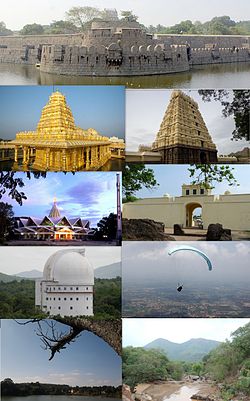
 Clockwise from the top: Vellore Fort, Assumption Cathedral, Jalakandeswarar Temple, Christian Medical College & Hospital, Vellore Institute of Technology Campus, Amirthi Zoological Park, Paragliding at Yelagiri and Srilakshmi Golden Temple | |
| Nickname: Fort City / Second Madras / Medical Hub of India | |
| Coordinates: 12°54′59″N 79°07′57″E / 12.916500°N 79.132500°E | |
| Country | |
| State | Tamil Nadu |
| Region | Tondai Nadu |
| District | Vellore |
| Zones | Vellore North (Katpadi)
Vellore East (Sathuvachari) Vellore South (Vellore Fort) Vellore West (Konavattam) |
| Smart City Ranking India | Tenth |
| Metropolitan Area | • Vellore
• Ratnagiri keelminnal • Melvisharam • Ranipettai • Arcot • Walajapettai • Vellore Airport • Pallikonda • Virinjipuram • Latteri • Tiruvalam • Kaniyambadi • Balamathi • Usoor • Serkadu |
| Founded by | Unknown |
| Named for | Heritage and culture |
| Government | |
| • Body | Vellore Municipal Corporation Vellore Metropolitan Area |
| Area | |
| • Metro | 87.915 km2 (33.944 sq mi) |
| Elevation | 239 m (784 ft) |
| Population (2011)[2] | |
| • City | 504,079 |
| • Rank | 7th in Tamil Nadu |
| • Metro | 687,981 |
| Demonym(s) | Vellorekaran, Vellorian |
| Language | |
| • Official | Tamil |
| Time zone | UTC+5:30 (IST) |
| PIN | 632 ××× |
| Telephone code | 91-416 |
| Vehicle registration | TN 23 |
| Distance from Chennai City limits | 135 kilometres (84 mi) |
| Planning agency | Vellore Municipal Corporation |
| Website | www |
Vellore (English: VAY-loor), also natively spelt as Velur,[note 1] is a sprawling city and the administrative headquarters of Vellore district in the Indian state of Tamil Nadu. It is located on the banks of the Palar River in the northeastern part of Tamil Nadu and is separated into four zones that are further subdivided into 60 wards, covering an area of 87.915 km2 and housing a population of 423,425 as reported by the 2001 census.[1][3] It is located about 137.20 kilometres (85 mi) west of Chennai, and about 213.20 kilometres (132 mi) east of Bangalore. Vellore is located on the Mumbai–Chennai arm of the Golden Quadrilateral. Vellore is governed under a mayor and the Vellore Municipal Corporation. It is a part of both the Lok Sabha and state assembly constituencies of Vellore.
Vellore is the home to Christian Medical College & Hospital,[4] the Vellore Institute of Technology (VIT)[5] and Sripuram Golden Temple.
The Vellore region is the largest exporter of finished leather goods in the country. Leather exports from Vellore account for more than 37% of India's leather exports and leather-related products.[6]
Vellore is one of 27 cities chosen by the Government of India to take part in the country's Smart Cities Mission.[7]
- ^ a b "Vellore Corporation GO No.221 dated 28.09.2010" (PDF). Government of Tamil Nadu. Retrieved 18 February 2014.
- ^ "Vellore Corporation - Population". Commissionerate of Municipal Administration - Tamil Nadu. Archived from the original (XLS) on 15 March 2016. Retrieved 22 October 2020.
- ^ "Extended Vellore Corporation to have 60 divisions". The Hindu.
- ^ "CMC exhibition focuses on pregnancy and diabetes". The Hindu. Retrieved 26 February 2017.
- ^ "Home". vit.ac.in.
- ^ "Activities and schemes operated by District Industries Centre, Vellore district". Vellore District Administration. Retrieved 7 July 2013.
- ^ Staff Reporter (21 September 2016). "Vellore makes it to smart cities list". The Hindu. ISSN 0971-751X. Retrieved 6 January 2020.
Cite error: There are <ref group=note> tags on this page, but the references will not show without a {{reflist|group=note}} template (see the help page).
© MMXXIII Rich X Search. We shall prevail. All rights reserved. Rich X Search

